We're pleased to announce that our bid, for a comprehensive online campaigning toolkit to assist cycle campaign groups around the UK, is a winner in the GeoVation contest!
It brings £27,000 for the development of a toolkit which, in the words of one supporter, should be "a hugely important step forward for all cycle campaigning groups".
Our bid was one of 155 ideas submitted to the GeoVation challenge, on the theme of "How can we improve transport in Britain?". Our bid was shortlisted, and we attended the GeoVation Camp in March to help develop the proposal amongst a total of 30 ideas invited. We were one of the final ten proposals, and took part in a Dragon's Den -style pitch on Wednesday.
We were delighted to be picked as one of the winners who share the £150k pot of funding.


Photos by Ordnance Survey, licenced CC BY-NC 2.0
Martin Lucas-Smith, who presented the bid alongside CycleStreets' routemaster, Simon Nuttall, said:
"We were delighted to be picked by the Ordnance Survey's judges as one of the winners. The £27,000 of funding will enable us to get this much-needed project off the ground.
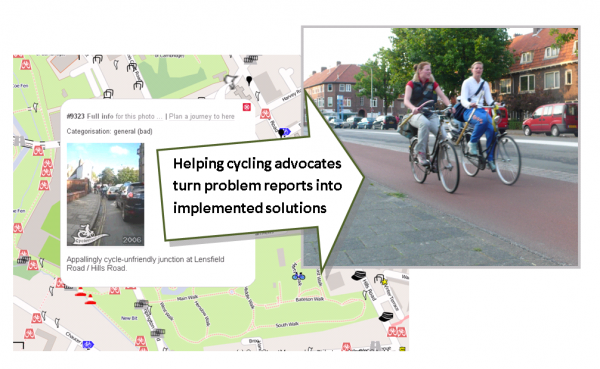
"As a member of one of the many local cycle campaign groups who will benefit, I'm all too aware of the large number of issues on the street network that need improvement, and the difficulty of managing this deluge of problems.
"The new system will help campaigners around the country convert these problem reports into prioritised, well-evidenced solution proposals. It should help them work more productively with local councils to see changes implemented."
We'd like to thank all the groups who provided quotes of support for our bid, including the CTC, Cyclenation, London Cycling Campaign, and a variety of groups around the country. We're working to provide you with a really great, useful and user-friendly system that will save a lot of time and effort.
Some of the things the new system will be able to do are:
- Enable members of the public and campaigners easily to pinpoint where cycling is difficult
- Help groups prioritise what to work on
- Pull in planning application data automatically, so that potential issues needing attention are readily accessible
- Automatically notify and involve people who cycle through an area – who therefore have an interest in seeing issues fixed
- Make geographical data such as collision data and accessibility analysis easily available, to provide context
- Enable simpler and more focussed discussion based on specific issues, groups of issues, or themes
- Enable best practice to be 'pulled-in' to discussions, by providing off-the-shelf examples shared from elsewhere in the UK
- Enable groups to include LA contacts in these discussions if they wish
- Enable groups to assemble 'solution' resources so that problems can be resolved on the ground
- Give groups a variety of ways of publishing their activity on their website easily.
GeoVation is run by the Ordnance Survey, and uses funding from the Technology Strategy Board and Ideas In Transit, and the Department for Transport. It runs challenges to address specific needs within communities, which may be satisfied in part through the use of geography.
We'll have more details soon about the next steps. As the plans develop, we'll be issuing calls for comments from groups in the cycling community, before we start with any coding.